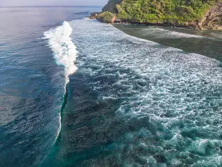
BMKG warns of waves up to 3,5 metres in East Nusa Tenggara
BMKG forecast waves of up to 3,5 metres in East Nusa Tenggara on Oct. 7, with the western Sumba Strait facing the highest risk for ferry navigation.
By Pandi Muktar
Editor: Mursyid Sonsang
· 2 min read
Ende — Indonesia’s Meteorology, Climatology and Geophysical Agency (BMKG) warned on Oct. 7 that waves of up to 3,5 metres could affect waters around East Nusa Tenggara, with conditions expected from 08.00 WITA through the morning of Oct. 8.
The warning covered waters where waves of 1,25 to 2,5 metres were forecast, as well as the western part of the Sumba Strait, where waves of 2,5 to 3,5 metres were possible. BMKG forecaster Nimrot Adipapa Sipa of the Tenau-Kupang station said the higher waves could threaten navigation safety, particularly for ferries.
Why it matters for sea users in East Nusa Tenggara
For foreign visitors and residents using ferries or other vessels in the province, the warning means that sea conditions may be hazardous during the stated period. The report specifically identifies the western Sumba Strait as the area facing the highest forecast waves and ferries as especially exposed to the safety risk.
The forecast described generally partly cloudy conditions over East Nusa Tenggara’s waters, with winds blowing from the northeast to southeast. The report did not state a closure of ports or ferry routes, nor did it provide a broader travel restriction. It said the higher-wave conditions were expected to continue until the morning of Oct. 8.
Sources
Read next
More on this story

Visas & Immigration
Denpasar Detention Center Deports Eight Foreigners Over Violations
Denpasar immigration officials deported eight foreigners between Sept. 30 and Oct. 7 after violations including prostitution-related activity, invalid…
Most read in Environment

Related