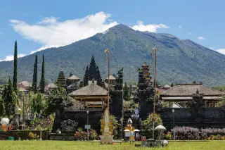
Two hikers found safe after overnight search on Mount Agung
Two young hikers who went missing while descending Mount Agung on 8 September 2026 were found alive in a ravine the following day, after a multi-agency search focused on forested slopes around 2,800 metres above sea level.
Editor: Mursyid Sonsang
· Event date: · 3 min read

Karangasem — — Two young hikers who went missing while descending Mount Agung in eastern Bali on 8 September 2026 were located alive the following day in a ravine at around 2,000 metres above sea level, according to search and rescue officials and local media.
The hikers were identified as Piqri Zaenal Abidin, 20, and Lorenzo Regiraldo Tawang, 23. They began their ascent via the Pos Pura Pasar Agung route in Selat district at about 02:00 WITA on Tuesday, 8 September 2026, according to the Denpasar Search and Rescue Office. During their descent that afternoon, they reportedly lost the trail in forested terrain and became stranded off the official route.
Contact with the pair was last recorded at around 17:30 WITA on Tuesday, when they were believed to be in a forested area on the mountain at an elevation near 2,800 metres above sea level. After that call, their phones could no longer be reached, prompting relatives and companions to report them missing to the Denpasar search and rescue office on Wednesday morning, 9 September.
Search teams deploy on upper Mount Agung
The Denpasar Search and Rescue Office (Basarnas) coordinated a joint operation involving the Karangasem disaster management agency, local military and police units, firefighters, health staff from Selat Community Health Centre and local Pasar Agung guides. According to the head of the Denpasar Search and Rescue Office, I Nyoman Sidakarya, three search and rescue units were formed to sweep different sections of the mountain.
Teams focused initially on forested slopes at around 2,800 metres above sea level, based on information about the hikers’ last known position. During the sweep, searchers found a walking stick believed to belong to one of the hikers at approximately 2,854 metres above sea level. This discovery was used as a reference point to determine search directions but did not directly reveal the hikers’ location.
Local media reports described steep, forested terrain and cloud, rain and reduced visibility that complicated the search. Despite these conditions, teams continued to descend and traverse ravines and river gullies on the mountain’s slopes.
Missing hikers found in ravine and evacuated
By early afternoon on Wednesday, 9 September 2026, one of the search units reported finding the two hikers in a ravine area at an altitude of about 2,000 metres above sea level, in a river gully on the slopes of Mount Agung. Koordinator Pos Pencarian dan Pertolongan Basarnas Karangasem, I Putu Handika Bhayangkara, said the pair were located at around 13:30 WITA.
According to Handika, both hikers were in safe condition, suffering mainly from fatigue after spending the night in steep terrain away from established trails. They did not show signs of serious injury, as they had not fallen deeply or experienced additional accidents, local media reported.
Rescue teams assisted the pair back up from the ravine and escorted them down to Pos Pura Pasar Agung. The hikers arrived at the post at about 16:45 WITA on Wednesday, where they received medical checks and treatment for exhaustion from Selat Community Health Centre staff.
Officials from Basarnas and local outlets later confirmed that the operation had concluded with both hikers safely evacuated from Mount Agung. The case has drawn attention among visitors and local climbers as a reminder of the challenges presented by Mount Agung’s steep, forested slopes and the importance of following marked routes and guidance from local mountain authorities.
Sources
Next story
Indonesia Deports Australian Man From Bali, Imposes 10-Year Re-Entry Ban
Indonesian immigration authorities said they deported a 28-year-old Australian identified as BA to Brisbane and imposed a 10-year re-entry ban after a…
Related